
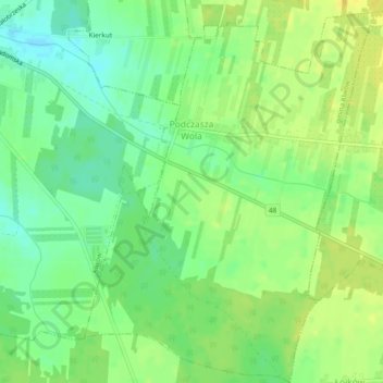
Carte topographique Podczasza Wola
Carte interactive
Cliquez sur la carte pour afficher l’altitude.
À propos de cette carte
Nom : Carte topographique Podczasza Wola, altitude, relief.
Altitude moyenne : 168 m
Altitude minimum : 156 m
Altitude maximum : 179 m
Autres cartes topographiques
Cliquez sur une carte pour visualiser sa topographie, son altitude et son relief.
Wysokin
Poland > Masovian Voivodeship > Przysucha County
Wysokin, gmina Odrzywół, Przysucha County, Masovian Voivodeship, 26-425, Poland
Altitude moyenne : 152 m
Kozłowiec
Poland > Masovian Voivodeship > Przysucha County
Kozłowiec, gmina Przysucha, Przysucha County, Masovian Voivodeship, Poland
Altitude moyenne : 264 m
Przysucha
Poland > Masovian Voivodeship > Przysucha County > Przysucha > Przysucha
Przysucha, gmina Przysucha, Przysucha County, Masovian Voivodeship, 26-400, Poland
Altitude moyenne : 227 m
Ruski Bród
Poland > Masovian Voivodeship > Przysucha County
Ruski Bród, gmina Przysucha, Przysucha County, Masovian Voivodeship, Poland
Altitude moyenne : 269 m