
Carte topographique Oodweyne District
Carte interactive
Cliquez sur la carte pour afficher l’altitude.
À propos de cette carte
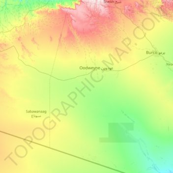
Nom : Carte topographique Oodweyne District, altitude, relief.
Lieu : Oodweyne District, Togdheer, Somalia (8.57202 44.69000 9.94019 45.29000)
Altitude moyenne : 1 091 m
Altitude minimum : 767 m
Altitude maximum : 1 900 m
Autres cartes topographiques
Cliquez sur une carte pour visualiser sa topographie, son altitude et son relief.
Forestry
Somalia > Togdheer > Burao District
Forestry, Burao District, Togdheer, Somalia
Altitude moyenne : 934 m
Burao
Somalia > Togdheer > Burao District
Burao, Burao District, Togdheer, Somaliland, Somalia
Altitude moyenne : 1 051 m
Ceegaag
Somalia > Togdheer > Buhoodle District > Ceegaag
Ceegaag, Buhoodle District, Togdheer, Somaliland, Somalia
Altitude moyenne : 840 m
Togdheer
Somalia > Togdheer > Burao District
Togdheer, Burao District, Togdheer, Somaliland, Somalia
Altitude moyenne : 930 m