
Carte topographique Grabsleben
Cliquez sur la carte pour afficher l’altitude.
À propos de cette carte
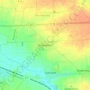
Nom : Carte topographique Grabsleben, altitude, relief.
Altitude moyenne : 291 m
Altitude minimum : 272 m
Altitude maximum : 310 m
Autres cartes topographiques
Cliquez sur une carte pour visualiser sa topographie, son altitude et son relief.
Gotha
Germany > Thuringia > Landkreis Gotha
Gotha is situated in a flat landscape within the fertile Thuringian Basin. A tectonic dislocation traverses the city from north-west to south-east. Thereby, it forms three prominent hills: the 431 m high Krahnberg with the Ratsholz forest in the north-west, the hill of Friedenstein Castle in the city centre…
Altitude moyenne : 320 m