
Carte topographique Strasburg
Carte interactive
Cliquez sur la carte pour afficher l’altitude.
À propos de cette carte
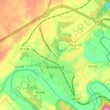
Nom : Carte topographique Strasburg, altitude, relief.
Lieu : Strasburg, Shenandoah County, Virginia, United States (38.97303 -78.39057 39.01455 -78.32873)
Altitude moyenne : 195 m
Altitude minimum : 117 m
Altitude maximum : 293 m
According to the United States Census Bureau, the town has a total area of 3.2 square miles (8.2 km2), of which, 3.2 square miles (8.2 km2) of it is land and 0.04 square miles (0.1 km2) of it (0.63%) is water. The elevation of the area is 578 ft (176 m).
Autres cartes topographiques
Cliquez sur une carte pour visualiser sa topographie, son altitude et son relief.
Mount Jackson
United States > Virginia > Shenandoah County
Mount Jackson, Shenandoah County, Virginia, United States
Altitude moyenne : 306 m
New Market
United States > Virginia > Shenandoah County
New Market, Shenandoah County, Virginia, 22844, United States
Altitude moyenne : 310 m
Bonnet Hill
United States > Virginia > Shenandoah County
Bonnet Hill, Shenandoah County, Virginia, United States
Altitude moyenne : 391 m
Woodstock
United States > Virginia > Shenandoah County
Woodstock, Shenandoah County, Virginia, United States
Altitude moyenne : 252 m