
Faire un don
Équipez-vous pour votre prochaine aventure :
En tant que Partenaire Amazon, ce site perçoit une commission sur les achats éligibles sans surcoût pour vous.
Carte topographique Purulia
Cliquez sur la carte pour afficher l’altitude.
Faire un don
Équipez-vous pour votre prochaine aventure :
En tant que Partenaire Amazon, ce site perçoit une commission sur les achats éligibles sans surcoût pour vous.
Purulia
Several rivers flow across Purulia district. Among these Kangsabati, Kumari, Silabati (silai), Dwarakeswar, Subarnarekha and Damodar are the important ones. Although several rivers flows across the district, 50% of the water run off due to the undulated topography. There are also several Small dams like Futiyary, Murguma, Pardi, Burda, Gopalpur, which are mainly used for irrigation of agriculture field. Saheb Bandh is one of the popular and famous waterbodies of Purulia. It is located in the heart of the purulia town. It is a shelter of the migratory birds which comes from Bangladesh, Burma, Sindh, Baluchistan during December to March.
Faire un don
Équipez-vous pour votre prochaine aventure :
En tant que Partenaire Amazon, ce site perçoit une commission sur les achats éligibles sans surcoût pour vous.
À propos de cette carte
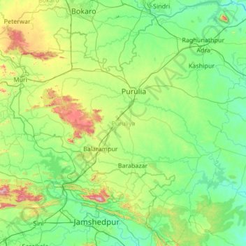
Nom : Carte topographique Purulia, altitude, relief.
Lieu : Purulia, West Bengal, India (22.70500 85.81967 23.69920 86.90633)
Altitude moyenne : 225 m
Altitude minimum : 86 m
Altitude maximum : 891 m
Faire un don
Équipez-vous pour votre prochaine aventure :
En tant que Partenaire Amazon, ce site perçoit une commission sur les achats éligibles sans surcoût pour vous.
Autres cartes topographiques
Cliquez sur une carte pour visualiser sa topographie, son altitude et son relief.
Faire un don
Équipez-vous pour votre prochaine aventure :
En tant que Partenaire Amazon, ce site perçoit une commission sur les achats éligibles sans surcoût pour vous.
Maheshtala
India > West Bengal > Thakurpukur Maheshtala
Maheshtala is located at 22°30′31″N 88°15′12″E / 22.5086210°N 88.2532182°E / 22.5086210; 88.2532182. It has an average elevation of 9 metres (30 ft).
Altitude moyenne : 5 m
Faire un don
Équipez-vous pour votre prochaine aventure :
En tant que Partenaire Amazon, ce site perçoit une commission sur les achats éligibles sans surcoût pour vous.
Durgapur
India > West Bengal > Faridpur Durgapur
Durgapur is located at 23°33′N 87°19′E / 23.55°N 87.32°E / 23.55; 87.32. It has an average elevation of 65 metres (213 ft).
Altitude moyenne : 76 m
Bardhaman
India > West Bengal > Burdwan - I
The region has an average elevation of 40 metres (131 ft). The city is situated 1100 km from New Delhi and a little less than 100 km north-west of Kolkata on the Grand Trunk Road (National Highway 19) and Eastern Railway. The chief rivers are the Damodar and the Banka.
Altitude moyenne : 31 m
Purulia
India > West Bengal > Purulia - II
Purulia is located at 23°20′N 86°22′E / 23.33°N 86.37°E / 23.33; 86.37. It has an average elevation of 228 metres (748 feet).
Altitude moyenne : 241 m
Faire un don
Équipez-vous pour votre prochaine aventure :
En tant que Partenaire Amazon, ce site perçoit une commission sur les achats éligibles sans surcoût pour vous.
Naihati
India > West Bengal > Barrackpur - I > Naihati
Naihati is located at 22°54′N 88°25′E / 22.9°N 88.42°E / 22.9; 88.42. It has an average elevation of 15 metres (49 feet).
Altitude moyenne : 9 m
Singur
India > West Bengal > Singur > Singur
Singur is located at 22°49′N 88°14′E / 22.81°N 88.23°E / 22.81; 88.23. It has an average elevation of 14 metres (45 ft), and is situated on the Ganges delta.
Altitude moyenne : 9 m
Faire un don
Équipez-vous pour votre prochaine aventure :
En tant que Partenaire Amazon, ce site perçoit une commission sur les achats éligibles sans surcoût pour vous.
Ilam Bazar
India > West Bengal > Illambazar > Ilam Bazar
Ilambazar is located at 23°38′N 87°32′E / 23.63°N 87.53°E / 23.63; 87.53. It has an average elevation of 54 m (177 ft).
Altitude moyenne : 58 m
Rajpur Sonarpur
India > West Bengal > Sonarpur > Rajpur Sonarpur
Rajpur Sonarpur is located at 22°26′18″N 88°25′55″E / 22.4382026°N 88.4320450°E / 22.4382026; 88.4320450. It has an average elevation of 9 metres (30 ft).
Altitude moyenne : 4 m
Faire un don
Équipez-vous pour votre prochaine aventure :
En tant que Partenaire Amazon, ce site perçoit une commission sur les achats éligibles sans surcoût pour vous.
Siuri
India > West Bengal > Suri - I > Siuri
Suri is located at 23°54′36″N 87°31′37″E / 23.910°N 87.527°E / 23.910; 87.527. Suri is 220 km from State capital Kolkata (Calcutta), 90 km from Durgapur, 34 km from Bolpur–Santiniketan, 55 km from Andal and 19 km from Sainthia on the Andal–Sainthia branch line of Eastern Railway. It is…
Altitude moyenne : 66 m
Faire un don
Équipez-vous pour votre prochaine aventure :
En tant que Partenaire Amazon, ce site perçoit une commission sur les achats éligibles sans surcoût pour vous.