
Carte topographique Rubaga
Carte interactive
Cliquez sur la carte pour afficher l’altitude.
À propos de cette carte
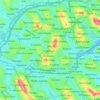
Nom : Carte topographique Rubaga, altitude, relief.
Lieu : Rubaga, Kampala, Central Region, Uganda (0.27082 32.50988 0.35101 32.57710)
Altitude moyenne : 1 187 m
Altitude minimum : 1 145 m
Altitude maximum : 1 310 m
Autres cartes topographiques
Cliquez sur une carte pour visualiser sa topographie, son altitude et son relief.
Kigoowa I
Uganda > Central Region > Kampala
Kigoowa I, Kampala, Central Region, Uganda
Altitude moyenne : 1 194 m
Nakawa
Uganda > Central Region > Kampala
Nakawa, Kampala, Central Region, Uganda
Altitude moyenne : 1 178 m
Pepsi
Uganda > Central Region > Kampala
Pepsi, Kampala, Central Region, Uganda
Altitude moyenne : 1 171 m
1p
Uganda > Central Region > Kampala
1p, Nakawa, Kampala, Central Region, Uganda
Altitude moyenne : 1 183 m
Wansanso (zone)
Uganda > Central Region > Kampala
Wansanso (zone), Kibuye II, Makindye, Kampala, Central Region, Uganda
Altitude moyenne : 1 183 m
Flat
Uganda > Central Region > Kampala
Flat, Kampala, Central Region, Uganda
Altitude moyenne : 1 191 m
Nazareth
Uganda > Central Region > Kampala
Nazareth, Kampala, Central Region, Uganda
Altitude moyenne : 1 177 m
Utc
Uganda > Central Region > Kampala > Utc
Utc, Kampala, Central Region, Uganda
Altitude moyenne : 1 188 m
Central
Uganda > Central Region > Kampala
Central, Kampala, Central Region, Uganda
Altitude moyenne : 1 193 m
Universal
Uganda > Central Region > Kampala
Universal, Kampala, Central Region, Uganda
Altitude moyenne : 1 184 m
Isreal-matovu
Uganda > Central Region > Kampala
Isreal-matovu, Kampala, Central Region, Uganda
Altitude moyenne : 1 187 m
Boston
Uganda > Central Region > Kampala > Boston
Boston, Kampala, Central Region, 12416, Uganda
Altitude moyenne : 1 182 m
Makindye
Uganda > Central Region > Kampala
Makindye, Kampala, Central Region, Uganda
Altitude moyenne : 1 160 m