
Carte topographique Bodø - Bådåddjo
Carte interactive
Cliquez sur la carte pour afficher l’altitude.
À propos de cette carte
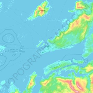
Nom : Carte topographique Bodø - Bådåddjo, altitude, relief.
Lieu : Bodø - Bådåddjo, Bodø, Nordland, 8005, Norway (67.12443 14.22175 67.44443 14.54175)
Altitude moyenne : 74 m
Altitude minimum : -3 m
Altitude maximum : 1 130 m
Snow cover during winter varies, and is often sparse or lacking in the city center, while being more reliable only slightly inland or at some altitude. The largest recorded snow depth at the airport is 90 centimetres (35 in) in February 1976. Located on a peninsula in the Norwegian Sea, Bodø is known to be a city with potential for strong winds, both from southwest and east.
Autres cartes topographiques
Cliquez sur une carte pour visualiser sa topographie, son altitude et son relief.
Haukland Beach
Haukland Beach, Sjøbakken, Vestvågøy, Nordland, Norway
Altitude moyenne : 103 m
Ballangen - Bálák
Ballangen - Bálák, Narvik, Nordland, Norway
Altitude moyenne : 91 m
Sulitjelma - Sulisjielmmá
Sulitjelma - Sulisjielmmá, Fauske, Nordland, Norway
Altitude moyenne : 379 m