
Carte topographique Lake O'Hara
Carte interactive
Cliquez sur la carte pour afficher l’altitude.
À propos de cette carte
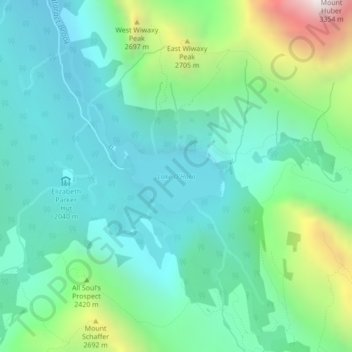
Nom : Carte topographique Lake O'Hara, altitude, relief.
Altitude moyenne : 2 276 m
Altitude minimum : 1 969 m
Altitude maximum : 3 232 m
Lake O'Hara is a lake at an elevation of 2,020 metres (6,630 ft) in the alpine area of Yoho National Park, in the province of British Columbia, on the western side of the Great Divide with the province of Alberta and Banff National Park to the east. The lake and the valley are accessible through a bus service that is run by Parks Canada or by an 11 km hike along a road with an elevation gain of approximately 500m.
Autres cartes topographiques
Cliquez sur une carte pour visualiser sa topographie, son altitude et son relief.
McMurdo
Canada > British Columbia > Columbia-Shuswap Regional District > Area A (Kicking Horse/Kinbasket Lake)
McMurdo, Area A (Kicking Horse/Kinbasket Lake), Columbia-Shuswap Regional District, British Columbia, V0A 1H7, Canada
Altitude moyenne : 855 m