
Carte topographique Dasmariñas
Carte interactive
Cliquez sur la carte pour afficher l’altitude.
À propos de cette carte
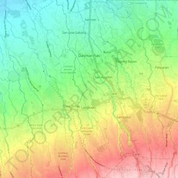
Nom : Carte topographique Dasmariñas, altitude, relief.
Lieu : Dasmariñas, Cavite, Calabarzon, Philippines (14.24820 120.92052 14.36373 121.01164)
Altitude moyenne : 125 m
Altitude minimum : 28 m
Altitude maximum : 269 m
Dasmariñas is partly lowland and partly hilly. The Poblacion itself is elevated. From an elevation of 80 meters (260 ft) at the Poblacion, the land rises to 250 meters (820 ft) towards Silang. Generally, land near rivers and creeks are rugged. Dasmariñas is outside the typhoon belt and has no fault line constraints. Further, it is served by natural drainage system since it is traversed by several rivers and water tributaries draining to the Manila Bay. The city has not yet to experience floods.
Autres cartes topographiques
Cliquez sur une carte pour visualiser sa topographie, son altitude et son relief.
Trece Martires
Trece Martires, Cavite, Calabarzon, 4109, Philippines
Altitude moyenne : 142 m
Amadeo
Philippines > Cavite > Amadeo
Amadeo, Cavite, Calabarzon, 4119, Philippines
Altitude moyenne : 375 m
Washington Place
Philippines > Cavite > Washington Place
Washington Place, Cavite, Calabarzon, 4114, Philippines
Altitude moyenne : 192 m
Manggahan
Philippines > Cavite > General Trias > Manggahan
Manggahan, General Trias, Cavite, Calabarzon, 4126, Philippines
Altitude moyenne : 124 m
Anabu III-A
Philippines > Cavite > Imus > Anabu III-A
Anabu III-A, Imus, Cavite, Calabarzon, 4103, Philippines
Altitude moyenne : 38 m
San Francisco
Philippines > Cavite > General Trias > San Francisco
San Francisco, General Trias, Cavite, Calabarzon, 4107, Philippines
Altitude moyenne : 89 m