
Faire un don
Équipez-vous pour votre prochaine aventure :
En tant que Partenaire Amazon, ce site perçoit une commission sur les achats éligibles sans surcoût pour vous.
Carte topographique Strathcona Science Provincial Park
Cliquez sur la carte pour afficher l’altitude.
Faire un don
Équipez-vous pour votre prochaine aventure :
En tant que Partenaire Amazon, ce site perçoit une commission sur les achats éligibles sans surcoût pour vous.
Strathcona Science Provincial Park
The park is situated in the North Saskatchewan River valley, on both banks of the river, at an elevation of 625 m (2,051 ft) and has a surface of 2.9 km2 (1.1 sq mi). It was established on December 12, 1979 and is maintained by Alberta Tourism, Parks and Recreation.
Faire un don
Équipez-vous pour votre prochaine aventure :
En tant que Partenaire Amazon, ce site perçoit une commission sur les achats éligibles sans surcoût pour vous.
À propos de cette carte
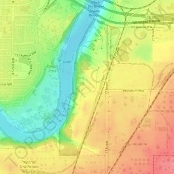
Nom : Carte topographique Strathcona Science Provincial Park, altitude, relief.
Altitude moyenne : 653 m
Altitude minimum : 608 m
Altitude maximum : 691 m
Faire un don
Équipez-vous pour votre prochaine aventure :
En tant que Partenaire Amazon, ce site perçoit une commission sur les achats éligibles sans surcoût pour vous.