
Carte topographique Saw Mill River
Carte interactive
Cliquez sur la carte pour afficher l’altitude.
À propos de cette carte
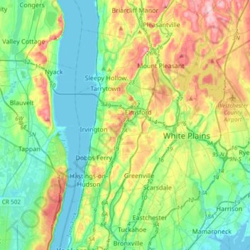
Nom : Carte topographique Saw Mill River, altitude, relief.
Altitude moyenne : 69 m
Altitude minimum : -2 m
Altitude maximum : 227 m
The Saw Mill River rises from a 1.75-acre (7,100 m2) pond in a wooded area of the town of New Castle roughly 2 miles (3.2 km) north of Chappaqua, a one-half mile (800 m) west of Quaker Road State Route 120 (NY 120) and just south of Stony Hollow Road, at an elevation of 490 feet (150 m) above sea level. It wends and meanders past a cemetery, between hills, through a residential area of houses on large wooded lots in a generally southward direction. Just north of Marcourt Drive, its first crossing, it is impounded to create another small pond. In this area it is frequently channelized and impounded as part of the landscaping on the area's large residential land lots. After crossing under Kipp Street, it bends eastward to cross under Quaker Road.