
Faire un don
Équipez-vous pour votre prochaine aventure :
En tant que Partenaire Amazon, ce site perçoit une commission sur les achats éligibles sans surcoût pour vous.
Carte topographique Crawinkel
Cliquez sur la carte pour afficher l’altitude.
Faire un don
Équipez-vous pour votre prochaine aventure :
En tant que Partenaire Amazon, ce site perçoit une commission sur les achats éligibles sans surcoût pour vous.
Crawinkel
Zu Crawinkel bemerkt Galletti in seiner topographisch-historischen Beschreibung des Gothaer Herzogtums von 1780.
Faire un don
Équipez-vous pour votre prochaine aventure :
En tant que Partenaire Amazon, ce site perçoit une commission sur les achats éligibles sans surcoût pour vous.
À propos de cette carte
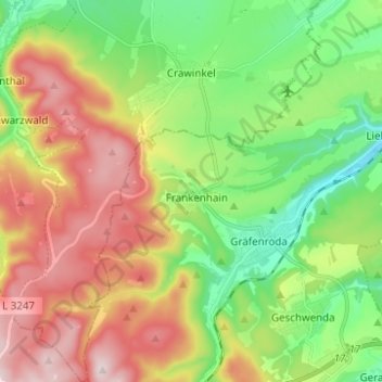
Nom : Carte topographique Crawinkel, altitude, relief.
Lieu : Crawinkel, Ohrdruf, Landkreis Gotha, Thüringen, Deutschland (50.71792 10.72425 50.79626 10.82820)
Altitude moyenne : 536 m
Altitude minimum : 366 m
Altitude maximum : 770 m
Faire un don
Équipez-vous pour votre prochaine aventure :
En tant que Partenaire Amazon, ce site perçoit une commission sur les achats éligibles sans surcoût pour vous.