
Carte topographique RIO SATIPO
Carte interactive
Cliquez sur la carte pour afficher l’altitude.
À propos de cette carte
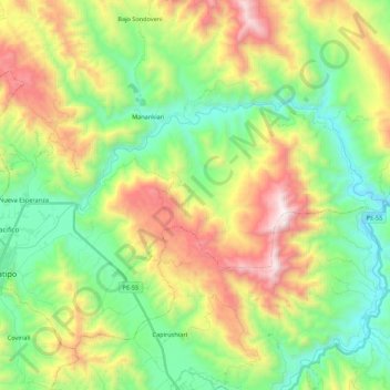
Nom : Carte topographique RIO SATIPO, altitude, relief.
Lieu : RIO SATIPO, Satipo, Provincia de Satipo, Junín, Perú (-11.26492 -74.64101 -11.16126 -74.42400)
Altitude moyenne : 962 m
Altitude minimum : 392 m
Altitude maximum : 1 971 m
Autres cartes topographiques
Cliquez sur une carte pour visualiser sa topographie, son altitude et son relief.
Plaza Mayor de Satipo
Plaza Mayor de Satipo, Satipo, Junín, Perú
Altitude moyenne : 669 m
Plaza de Armas Santa Leonor
Plaza de Armas Santa Leonor, Satipo, Junín, Perú
Altitude moyenne : 637 m
PLAZA DE ARMAS - JOSE OLAYA
PLAZA DE ARMAS - JOSE OLAYA, Villa Pacifico, Satipo, Provincia de Satipo, Junín, Perú
Altitude moyenne : 681 m