
Carte topographique Alegranza Island
Carte interactive
Cliquez sur la carte pour afficher l’altitude.
Alegranza Island
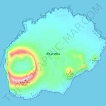
The area is 10.2 km². The island features a volcano with a crater of about 1.1 km in diameter and an altitude of 289 m. The second highest is Montaña de Lobos at 256 m and following La Rapagura. The northern portion is mainly flat.
À propos de cette carte
Nom : Carte topographique Alegranza Island, altitude, relief.
Lieu : Alegranza Island, Teguise, Las Palmas, Canary Islands, Spain (29.38263 -13.53188 29.41606 -13.48803)
Altitude moyenne : 39 m
Altitude minimum : 0 m
Altitude maximum : 289 m