
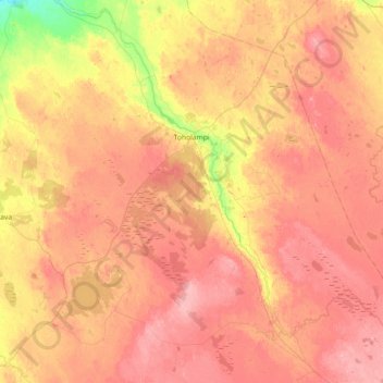
Carte topographique Toholampi
Carte interactive
Cliquez sur la carte pour afficher l’altitude.
À propos de cette carte
Nom : Carte topographique Toholampi, altitude, relief.
Altitude moyenne : 115 m
Altitude minimum : 50 m
Altitude maximum : 161 m
Autres cartes topographiques
Cliquez sur une carte pour visualiser sa topographie, son altitude et son relief.
Kaustinen
Finland > Central Ostrobothnia
Kaustinen, Kaustinen sub-region, Central Ostrobothnia, Western and Central Finland, Mainland Finland, 69600, Finland
Altitude moyenne : 79 m
Karhi
Finland > Central Ostrobothnia > Kokkola
Karhi, Kokkola, Kokkola sub-region, Central Ostrobothnia, Western and Central Finland, Mainland Finland, Finland
Altitude moyenne : 8 m
Kokkola
Finland > Central Ostrobothnia > Kokkola
Kokkola, Kokkola sub-region, Central Ostrobothnia, Western and Central Finland, Mainland Finland, Finland
Altitude moyenne : 28 m