
Faire un don
Équipez-vous pour votre prochaine aventure :
En tant que Partenaire Amazon, ce site perçoit une commission sur les achats éligibles sans surcoût pour vous.
Carte topographique North Pownal
Cliquez sur la carte pour afficher l’altitude.
Faire un don
Équipez-vous pour votre prochaine aventure :
En tant que Partenaire Amazon, ce site perçoit une commission sur les achats éligibles sans surcoût pour vous.
À propos de cette carte
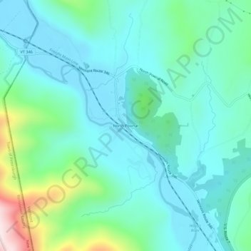
Nom : Carte topographique North Pownal, altitude, relief.
Altitude moyenne : 254 m
Altitude minimum : 144 m
Altitude maximum : 689 m
Faire un don
Équipez-vous pour votre prochaine aventure :
En tant que Partenaire Amazon, ce site perçoit une commission sur les achats éligibles sans surcoût pour vous.
Autres cartes topographiques
Cliquez sur une carte pour visualiser sa topographie, son altitude et son relief.
Peru
United States > Vermont > Bennington County
Peru is located in northeastern Bennington County, bordered by Rutland County to the north. The crest of the Green Mountains runs from north to the south through the western half of the town, traversed by the Long Trail/Appalachian Trail. 3,300-foot-high (1,000 m) Bromley Mountain and its ski area are in the…
Altitude moyenne : 595 m
Faire un don
Équipez-vous pour votre prochaine aventure :
En tant que Partenaire Amazon, ce site perçoit une commission sur les achats éligibles sans surcoût pour vous.
Manchester
United States > Vermont > Bennington County
Manchester is located in north-central Bennington County, lying between the Green Mountains to the east and the Taconic Range to the west. Equinox Mountain, the highest summit in the Taconics, with an elevation of 3,850 feet (1,170 m), is in the western part of the town. Manchester is drained by the Batten…
Altitude moyenne : 453 m
Faire un don
Équipez-vous pour votre prochaine aventure :
En tant que Partenaire Amazon, ce site perçoit une commission sur les achats éligibles sans surcoût pour vous.
Faire un don
Équipez-vous pour votre prochaine aventure :
En tant que Partenaire Amazon, ce site perçoit une commission sur les achats éligibles sans surcoût pour vous.
Peru
United States > Vermont > Bennington County
Peru is located in northeastern Bennington County, bordered by Rutland County to the north. The crest of the Green Mountains runs from north to the south through the western half of the town, traversed by the Long Trail/Appalachian Trail. 3,300-foot-high (1,000 m) Bromley Mountain and its ski area are in the…
Altitude moyenne : 595 m
Faire un don
Équipez-vous pour votre prochaine aventure :
En tant que Partenaire Amazon, ce site perçoit une commission sur les achats éligibles sans surcoût pour vous.
Manchester
United States > Vermont > Bennington County
Manchester is located in north-central Bennington County, lying between the Green Mountains to the east and the Taconic Range to the west. Equinox Mountain, the highest summit in the Taconics, with an elevation of 3,850 feet (1,170 m), is in the western part of the town. Manchester is drained by the Batten…
Altitude moyenne : 453 m
Faire un don
Équipez-vous pour votre prochaine aventure :
En tant que Partenaire Amazon, ce site perçoit une commission sur les achats éligibles sans surcoût pour vous.