
Carte topographique Hawkwell
Cliquez sur la carte pour afficher l’altitude.
À propos de cette carte
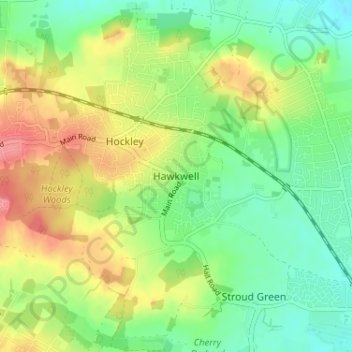
Nom : Carte topographique Hawkwell, altitude, relief.
Lieu : Hawkwell, Rochford, Essex, England, SS5 4EG, United Kingdom (51.57709 0.64641 51.61709 0.68641)
Altitude moyenne : 32 m
Altitude minimum : 1 m
Altitude maximum : 75 m
Autres cartes topographiques
Cliquez sur une carte pour visualiser sa topographie, son altitude et son relief.
Wallasea Island
United Kingdom > England > Essex > Rochford > Paglesham Church End
Altitude moyenne : 1 m