
Carte topographique Ernakulam district
Carte interactive
Cliquez sur la carte pour afficher l’altitude.
À propos de cette carte
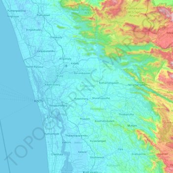
Nom : Carte topographique Ernakulam district, altitude, relief.
Lieu : Ernakulam district, Kerala, India (9.77369 76.16284 10.30322 77.08893)
Altitude moyenne : 201 m
Altitude minimum : -4 m
Altitude maximum : 1 826 m
The Ernakulam district covers an area of 3,068 km2 (1,185 sq mi) on the Western Coastal Plains of India. It is surrounded by the Thrissur District to the north, the Idukki District to the east, Alappuzha and Kottayam districts to the south and the Laccadive Sea to the west. The Anamalais occupy a large part of the district, consisting of the forest areas around Pooyamkutty and the Idamalayar Dam. The range also extends into Thrissur, Palakkad, and Idukki districts, as well as Coimbatore and Tiruppur districts of Tamil Nadu. The district is divided geographically into highland, midland, and coastal area. The altitude of the highlands is about 300 m (980 ft). The Periyar River, Kerala's longest, flows through all the taluks except Muvattupuzha. The Muvattupuzha River and a branch of the Chalakkudy River also flow through the district. The average yearly rainfall in the district is 3,432 mm (135.1 in). The district has a moderate climate and mostly falls within the Malabar Coast moist forests ecoregion, while the highlands are part of the South Western Ghats moist deciduous forests ecoregion. The Anamudi is the tallest peak in South India, on the border of Ernakulam and Idukki districts. Some parts of the Idamalayar Reserve Forest and Mankulam Forest Division have Sholas but these parts are inaccessible by road. Ernakulam district does not have a border with Tamil Nadu in some maps the district is shown incorrectly by adding areas of Idukki (which share border with Tamil nadu) as regions of Ernakulam. The Idamalayar Reserve Forest, and Edamalakkudy. Many types of sand, soil, and rocks are abundant here. Cochin International Airport is located in the northern part of the district at Nedumbassery, Kochi.
Autres cartes topographiques
Cliquez sur une carte pour visualiser sa topographie, son altitude et son relief.
Thiruvananthapuram
India > Kerala > Thiruvananthapuram
Thiruvananthapuram, Thiruvananthapuram District, Kerala, 695001, India
Altitude moyenne : 33 m
Western Ghats
Western Ghats, Idukki, Kerala, 685614, India
Altitude moyenne : 2 225 m
Vagamon Lake
India > Kerala > Peerumade > Vagamon
Vagamon Lake, Vagamon, Peerumade, Idukki District, Kerala, India
Altitude moyenne : 976 m
Thodupuzha
India > Kerala > Thodupuzha
Thodupuzha, Idukki District, Kerala, 685584, India
Altitude moyenne : 53 m
Suryanelli
India > Kerala > Udumbanchola
Suryanelli, Udumbanchola, Idukki District, Kerala, India
Altitude moyenne : 1 553 m
Kottakombur
Kottakombur, Devikulam, Idukki District, Kerala, India
Altitude moyenne : 1 919 m
Irinjalakuda
India > Kerala > Mukundapuram
Irinjalakuda, Mukundapuram, Thrissur District, Kerala, 680100, India
Altitude moyenne : 7 m
chullimanoor
India > Kerala > Nedumangad
chullimanoor, Nedumangad, Thiruvananthapuram District, Kerala, 695541, India
Altitude moyenne : 94 m
Santhanpara
India > Kerala > Udumbanchola > Choondal
Santhanpara, Choondal, Udumbanchola, Idukki District, Kerala, India
Altitude moyenne : 1 111 m
Poopara
India > Kerala > Udumbanchola
Poopara, Udumbanchola, Idukki District, Kerala, 685619, India
Altitude moyenne : 1 140 m
Puthencruz
India > Kerala > Kunnathunad
Puthencruz, Kunnathunad, Ernakulam District, Kerala, 682308, India
Altitude moyenne : 25 m
Kallara
India > Kerala > Nedumangad
Kallara, Nedumangad, Thiruvananthapuram District, Kerala, 695610, India
Altitude moyenne : 110 m
sree krishna swami temple pond
India > Kerala > Karthikappally > Kayamkulam
sree krishna swami temple pond, Puthuvel Harijan Colony, Kayamkulam, Karthikappally, Alappuzha District, Kerala, India
Altitude moyenne : 9 m
Murikkumthotti
India > Kerala > Udumbanchola
Murikkumthotti, Udumbanchola, Idukki District, Kerala, 685619, India
Altitude moyenne : 1 099 m
Cheruthapullur Kulam
Cheruthapullur Kulam, Alathur, Palakkad District, Kerala, India
Altitude moyenne : 90 m
kanthaloor pond 2
India > Kerala > Ottappalam > Vellinezhi
kanthaloor pond 2, Vellinezhi, Ottappalam, Palakkad District, Kerala, India
Altitude moyenne : 58 m
Mathoor
India > Kerala > Alathur > Kuzhalmannam
Mathoor, Kuzhalmannam, Alathur, Palakkad District, Kerala, 678571, India
Altitude moyenne : 75 m
Parumala
India > Kerala > Thiruvalla
Parumala, Thiruvalla, Pathanamthitta District, Kerala, 689626, India
Altitude moyenne : 6 m
Nellor Pond
India > Kerala > Chengannur
Nellor Pond, Chengannur, Alappuzha District, Kerala, India
Altitude moyenne : 6 m
Rajakkad
India > Kerala > Udumbanchola > Kalungu City
Rajakkad, Kalungu City, Udumbanchola, Idukki District, Kerala, 685566, India
Altitude moyenne : 855 m
Palvelicham
India > Kerala > Mananthavady
Palvelicham, Mananthavady, Wayanad District, Kerala, India
Altitude moyenne : 735 m
Adivaram
India > Kerala > Thamarassery
Adivaram, Thamarassery, Kozhikode District, Kerala, 673586, India
Altitude moyenne : 301 m
Karumalloor
India > Kerala > Paravur > Manjaly
Karumalloor, Manjaly, Paravur, Ernakulam District, Kerala, India
Altitude moyenne : 7 m
Velliangiri
Velliangiri, Mannarkad, Palakkad District, Kerala, India
Altitude moyenne : 1 307 m
Vellarikundu
India > Kerala > Vellarikkundu > Kadumeni
Vellarikundu, Kadumeni, Vellarikkundu, Kasaragod District, Kerala, India
Altitude moyenne : 85 m
Rajakumari
India > Kerala > Udumbanchola
Rajakumari, Udumbanchola, Idukki District, Kerala, 685619, India
Altitude moyenne : 1 001 m
Charakadvu
India > Kerala > Hosdurg > Karuvakkode
Charakadvu, Karuvakkode, Hosdurg, Kasaragod District, Kerala, 671316, India
Altitude moyenne : 25 m
Vavadukkam
India > Kerala > Kasaragod > Bedadka
Vavadukkam, Bedadka, Kasaragod, Kasaragod District, Kerala, India
Altitude moyenne : 133 m
Elanthoor
India > Kerala > Kozhencherry
Elanthoor, Kozhencherry, Pathanamthitta District, Kerala, 689643, India
Altitude moyenne : 38 m
Pallikkara
India > Kerala > Kunnathunad
Pallikkara, Kunnathunad, Ernakulam District, Kerala, 683565, India
Altitude moyenne : 12 m
Kottakkani
Kottakkani, Hosdurg, Kasaragod District, Kerala, 671316, India
Altitude moyenne : 23 m
Kizhakkekallada
Kizhakkekallada, Kollam, Kollam District, Kerala, 691502, India
Altitude moyenne : 10 m
Muttukadu colony
India > Kerala > Udumbanchola
Muttukadu colony, Udumbanchola, Idukki District, Kerala, India
Altitude moyenne : 1 193 m
Kundumkuzhy
Kundumkuzhy, Kasaragod, Kasaragod District, Kerala, 671541, India
Altitude moyenne : 137 m
Kuruva Island
India > Kerala > Sulthanbathery
Kuruva Island, Sulthanbathery, Wayanad District, Kerala, India
Altitude moyenne : 733 m
Pond at Kundamkuzhy near town
India > Kerala > Kasaragod > Kundumkuzhy
Pond at Kundamkuzhy near town, Kundumkuzhy, Kasaragod, Kasaragod District, Kerala, India
Altitude moyenne : 146 m
Beericheri
Beericheri, Hosdurg, Kasaragod District, Kerala, 671311, India
Altitude moyenne : 7 m