
Carte topographique Closter
Carte interactive
Cliquez sur la carte pour afficher l’altitude.
Closter
The topography gave a sense of isolation and protection, tucked behind the highest point of the Palisades and protected by limited access. Alternatively, sources indicate that the name derives from an early settler named Frederick Closter. Claims have been made that Frederick Closter is a myth that dates back to the 1940s.
À propos de cette carte
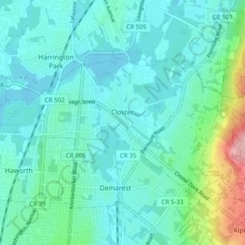
Nom : Carte topographique Closter, altitude, relief.
Lieu : Closter, Bergen County, New Jersey, 07624, United States (40.95748 -74.00184 40.98434 -73.93435)
Altitude moyenne : 32 m
Altitude minimum : 3 m
Altitude maximum : 165 m