
Carte topographique Chirnside
Carte interactive
Cliquez sur la carte pour afficher l’altitude.
À propos de cette carte
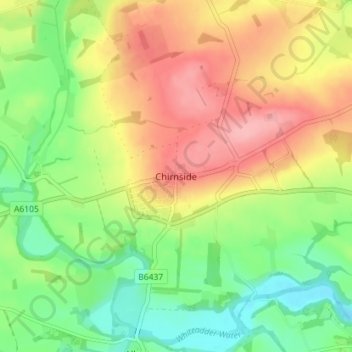
Nom : Carte topographique Chirnside, altitude, relief.
Altitude moyenne : 80 m
Altitude minimum : 27 m
Altitude maximum : 141 m
Autres cartes topographiques
Cliquez sur une carte pour visualiser sa topographie, son altitude et son relief.
Ayton
United Kingdom > Scotland > Scottish Borders
Ayton, Scottish Borders, Scotland, TD14 5RU, United Kingdom
Altitude moyenne : 75 m
Peebles
United Kingdom > Scotland > Scottish Borders
Peebles, Scottish Borders, Scotland, EH45 8SL, United Kingdom
Altitude moyenne : 275 m
Innerleithen
United Kingdom > Scotland > Scottish Borders
Innerleithen, Scottish Borders, Scotland, EH44 6HD, United Kingdom
Altitude moyenne : 292 m
Ruddenleys
United Kingdom > Scotland > Scottish Borders
Ruddenleys, Scottish Borders, Scotland, EH46 7BN, United Kingdom
Altitude moyenne : 319 m
Stow
United Kingdom > Scotland > Scottish Borders
Stow, Scottish Borders, Scotland, TD1 2QX, United Kingdom
Altitude moyenne : 268 m
Galashiels
United Kingdom > Scotland > Scottish Borders
Galashiels, Scottish Borders, Scotland, United Kingdom
Altitude moyenne : 221 m
Earlston
United Kingdom > Scotland > Scottish Borders > Earlston
Earlston, Scottish Borders, Scotland, TD4 6BX, United Kingdom
Altitude moyenne : 169 m
St Leonard's
United Kingdom > Scotland > Scottish Borders > Hawick
St Leonard's, Hawick, Scottish Borders, Scotland, TD9 0PA, United Kingdom
Altitude moyenne : 186 m
Weird Law
United Kingdom > Scotland > Scottish Borders
Weird Law, Scottish Borders, Scotland, ML12 6QS, United Kingdom
Altitude moyenne : 357 m
Bowden
United Kingdom > Scotland > Scottish Borders > Bowden
Bowden, Scottish Borders, Scotland, TD6 0SS, United Kingdom
Altitude moyenne : 181 m
Eildon
United Kingdom > Scotland > Scottish Borders > Newtown St Boswells
Eildon, Newtown St Boswells, Scottish Borders, Scotland, TD6 9HH, United Kingdom
Altitude moyenne : 137 m
Wauchope
United Kingdom > Scotland > Scottish Borders
Wauchope, Scottish Borders, Scotland, TD9 9TG, United Kingdom
Altitude moyenne : 239 m