
Carte topographique Asheboro
Carte interactive
Cliquez sur la carte pour afficher l’altitude.
À propos de cette carte
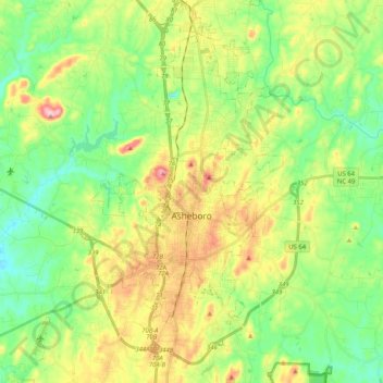
Nom : Carte topographique Asheboro, altitude, relief.
Lieu : Asheboro, Randolph County, North Carolina, United States (35.64477 -79.96995 35.79158 -79.76473)
Altitude moyenne : 208 m
Altitude minimum : 130 m
Altitude maximum : 343 m
Autres cartes topographiques
Cliquez sur une carte pour visualiser sa topographie, son altitude et son relief.
Franklinville
United States > North Carolina > Randolph County
Franklinville, Randolph County, North Carolina, United States
Altitude moyenne : 163 m
Ulah
United States > North Carolina > Randolph County
Ulah, Randolph County, North Carolina, 27205, United States
Altitude moyenne : 237 m
Redding Hills
United States > North Carolina > Randolph County > Asheboro > Redding Hills
Redding Hills, Asheboro, Randolph County, North Carolina, 27203, United States
Altitude moyenne : 223 m