
Carte topographique Schwarzer Berg
Carte interactive
Cliquez sur la carte pour afficher l’altitude.
À propos de cette carte
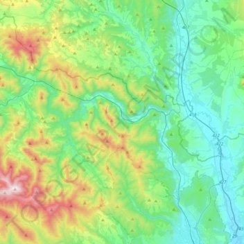
Nom : Carte topographique Schwarzer Berg, altitude, relief.
Altitude moyenne : 456 m
Altitude minimum : 190 m
Altitude maximum : 1 245 m
Autres cartes topographiques
Cliquez sur une carte pour visualiser sa topographie, son altitude et son relief.
Slanské Nové Mesto
Slowakei > Kaschauer Landschaftsverband > Bezirk Kaschau - Umgebung
Slanské Nové Mesto, Bezirk Kaschau - Umgebung, Kaschauer Landschaftsverband, Ostslowakei, 044 18, Slowakei
Altitude moyenne : 353 m
Tornau
Slowakei > Kaschauer Landschaftsverband > Bezirk Kaschau - Umgebung
Tornau, Bezirk Kaschau - Umgebung, Kaschauer Landschaftsverband, Ostslowakei, 044 02, Slowakei
Altitude moyenne : 394 m
Slanské Nové Mesto
Slowakei > Kaschauer Landschaftsverband > Bezirk Kaschau - Umgebung > Slanské Nové Mesto > Slanské Nové Mesto
Slanské Nové Mesto, Bezirk Kaschau - Umgebung, Kaschauer Landschaftsverband, Ostslowakei, 044 18, Slowakei
Altitude moyenne : 240 m