
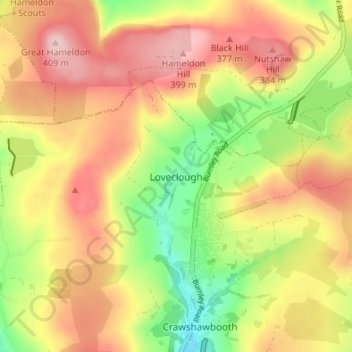
Carte topographique Loveclough
Carte interactive
Cliquez sur la carte pour afficher l’altitude.
À propos de cette carte
Nom : Carte topographique Loveclough, altitude, relief.
Altitude moyenne : 314 m
Altitude minimum : 205 m
Altitude maximum : 408 m
Autres cartes topographiques
Cliquez sur une carte pour visualiser sa topographie, son altitude et son relief.
Fold Head
United Kingdom > England > Lancashire > Borough of Rossendale > Healey
Fold Head, Whitworth, Healey, Borough of Rossendale, Lancashire, England, OL12 8XL, United Kingdom
Altitude moyenne : 294 m
Whitewell Bottom
United Kingdom > England > Lancashire > Borough of Rossendale > Sagar Holme
Whitewell Bottom, Sagar Holme, Borough of Rossendale, Lancashire, England, BB4 9DE, United Kingdom
Altitude moyenne : 281 m
Ewood Bridge
United Kingdom > England > Lancashire > Borough of Rossendale
Ewood Bridge, Borough of Rossendale, Lancashire, England, BB4 6LZ, United Kingdom
Altitude moyenne : 226 m
Clowbridge
United Kingdom > England > Lancashire > Borough of Rossendale > Habergham Eaves
Clowbridge, Habergham Eaves, Borough of Rossendale, Lancashire, England, United Kingdom
Altitude moyenne : 319 m
Irwell Springs
United Kingdom > England > Lancashire > Borough of Rossendale > Weir
Irwell Springs, Weir, Borough of Rossendale, Lancashire, England, OL13 8QX, United Kingdom
Altitude moyenne : 365 m
Whitworth
United Kingdom > England > Lancashire > Borough of Rossendale
Whitworth, Borough of Rossendale, Lancashire, England, United Kingdom
Altitude moyenne : 317 m
Rising Bridge
United Kingdom > England > Lancashire > Borough of Rossendale
Rising Bridge, Borough of Rossendale, Lancashire, England, BB5 2RY, United Kingdom
Altitude moyenne : 281 m
Stacksteads
United Kingdom > England > Lancashire > Borough of Rossendale
Stacksteads, Borough of Rossendale, Lancashire, England, OL13 0SG, United Kingdom
Altitude moyenne : 306 m
Rawtenstall
United Kingdom > England > Lancashire > Borough of Rossendale
Rawtenstall, Borough of Rossendale, Lancashire, England, BB4 7NE, United Kingdom
Altitude moyenne : 284 m
Stubbins
United Kingdom > England > Lancashire > Borough of Rossendale > Stubbins
Stubbins, Borough of Rossendale, Lancashire, North West England, England, BL0 0NN, United Kingdom
Altitude moyenne : 233 m
Edenfield
United Kingdom > England > Lancashire > Borough of Rossendale
Edenfield, Borough of Rossendale, Lancashire, England, BL0 0LB, United Kingdom
Altitude moyenne : 236 m