
Faire un don
Équipez-vous pour votre prochaine aventure :
En tant que Partenaire Amazon, ce site perçoit une commission sur les achats éligibles sans surcoût pour vous.
Carte topographique Mount Yangtai
Cliquez sur la carte pour afficher l’altitude.
Faire un don
Équipez-vous pour votre prochaine aventure :
En tant que Partenaire Amazon, ce site perçoit une commission sur les achats éligibles sans surcoût pour vous.
Mount Yangtai
The Mount Yangtai (Chinese: 羊台山; pinyin: Yángtaíshān), also known as Mount Yangtai Forest Park, is a mountain at the junction of Bao'an District and Nanshan District in Shenzhen, Guangdong, China. The peak is 587.3 metres (1,927 ft) in elevation, which is the highest peak in western Shenzhen. In 2008 The mount is rated as one of the eight scenic spots of Shenzhen by the Shenzhen government.
Faire un don
Équipez-vous pour votre prochaine aventure :
En tant que Partenaire Amazon, ce site perçoit une commission sur les achats éligibles sans surcoût pour vous.
À propos de cette carte
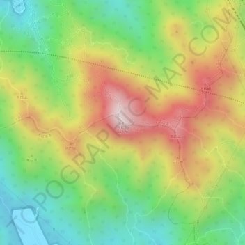
Nom : Carte topographique Mount Yangtai, altitude, relief.
Lieu : Mount Yangtai, Shenzhen, Guangdong, 518109, China (22.65439 113.95590 22.65449 113.95600)
Altitude moyenne : 287 m
Altitude minimum : 45 m
Altitude maximum : 557 m
Faire un don
Équipez-vous pour votre prochaine aventure :
En tant que Partenaire Amazon, ce site perçoit une commission sur les achats éligibles sans surcoût pour vous.
Autres cartes topographiques
Cliquez sur une carte pour visualiser sa topographie, son altitude et son relief.
Nanshan District
At 587 metres (1,926 ft) tall, Yangtaishan has the highest elevation in the district, with Tanglangshan being the second at 430 metres (1,411 ft), and Nanshan, third, at 336 metres (1,102 ft). The district has a total coastline of 55.18 kilometres (34.29 mi).
Altitude moyenne : 35 m
Faire un don
Équipez-vous pour votre prochaine aventure :
En tant que Partenaire Amazon, ce site perçoit une commission sur les achats éligibles sans surcoût pour vous.