
Carte topographique Xi'an
Cliquez sur la carte pour afficher l’altitude.
Xi'an
Xi'an lies on the Guanzhong Plain in the south-central part of Shaanxi province, on a flood plain created by the eight surrounding rivers and streams. The city has an average elevation of 400 metres (1,312 ft) above sea level and an annual precipitation of 553 mm (21.8 in). The urban area of Xi'an is located at 34°16′N 108°56′E / 34.267°N 108.933°E / 34.267; 108.933. The Wei River provides potable water to the city.
À propos de cette carte
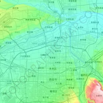
Nom : Carte topographique Xi'an, altitude, relief.
Lieu : Xi'an, Weiyang District, Xi'an, Shaanxi, 710018, China (34.18305 108.77508 34.50305 109.09508)
Altitude moyenne : 412 m
Altitude minimum : 350 m
Altitude maximum : 778 m