
Carte topographique Sankt Ingbert
Carte interactive
Cliquez sur la carte pour afficher l’altitude.
À propos de cette carte
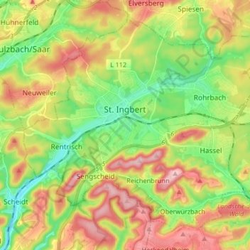
Nom : Carte topographique Sankt Ingbert, altitude, relief.
Lieu : Sankt Ingbert, Saarpfalz-Kreis, Saarland, 66386, Germany (49.23677 7.06207 49.30990 7.19357)
Altitude moyenne : 291 m
Altitude minimum : 200 m
Altitude maximum : 406 m
Autres cartes topographiques
Cliquez sur une carte pour visualiser sa topographie, son altitude et son relief.
Schüren
Germany > Saarland > Saarpfalz-Kreis > Sankt Ingbert
Schüren, St. Ingbert, Sankt Ingbert, Saarpfalz-Kreis, Saarland, Germany
Altitude moyenne : 307 m
Blieskastel
Germany > Saarland > Saarpfalz-Kreis
Blieskastel, Saarpfalz-Kreis, Saarland, 66440, Germany
Altitude moyenne : 294 m
Kirkel
Germany > Saarland > Saarpfalz-Kreis
Kirkel, Saarpfalz-Kreis, Saarland, 66459, Germany
Altitude moyenne : 278 m
Bexbach
Germany > Saarland > Saarpfalz-Kreis
Bexbach, Saarpfalz-Kreis, Saarland, 66450, Germany
Altitude moyenne : 308 m
Webenheim
Germany > Saarland > Saarpfalz-Kreis > Blieskastel
Webenheim, Blieskastel, Saarpfalz-Kreis, Saarland, Germany
Altitude moyenne : 276 m