
Carte topographique Jefferson
Carte interactive
Cliquez sur la carte pour afficher l’altitude.
À propos de cette carte
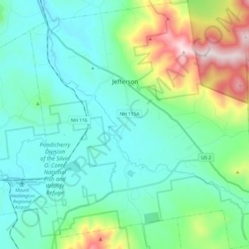
Nom : Carte topographique Jefferson, altitude, relief.
Lieu : Jefferson, Coös County, New Hampshire, 03583, United States (44.33323 -71.54324 44.46090 -71.38018)
Altitude moyenne : 493 m
Altitude minimum : 294 m
Altitude maximum : 1 208 m
Jefferson is located on U.S. Route 2 between Lancaster and Randolph, west of the midpoint between the Vermont and Maine borders. Set astride the broad Israel River valley, the town commands remarkable views of the Presidential Range and other White Mountain summits. Mount Starr King, with an elevation of 3,907 feet (1,191 m) and named for Thomas Starr King, is the highest point in town, near the town's northern border. It is regularly traversed by hikers scaling nearby 4,006-foot (1,221 m) Mount Waumbek, one of the "four-thousand footers"—the 48 peaks above 4,000 feet (1,200 m) in New Hampshire. Jefferson lies fully within the Connecticut River watershed.
Autres cartes topographiques
Cliquez sur une carte pour visualiser sa topographie, son altitude et son relief.
Mount Washington
United States > New Hampshire > Coos County
Mount Washington, Coös County, New Hampshire, United States
Altitude moyenne : 1 568 m
Millsfield
United States > New Hampshire > Coos County
Millsfield, Coös County, New Hampshire, United States
Altitude moyenne : 583 m
Jefferson Highland
United States > New Hampshire > Coos County > Jefferson
Jefferson Highland, Jefferson, Coös County, New Hampshire, 03583, United States
Altitude moyenne : 451 m
Blake Islands
United States > New Hampshire > Coos County > Errol
Blake Islands, Errol, Coös County, New Hampshire, United States
Altitude moyenne : 530 m
Pittsburg
United States > New Hampshire > Coos County
Pittsburg, Coös County, New Hampshire, United States
Altitude moyenne : 522 m
Dummer
United States > New Hampshire > Coos County
Dummer, Coos County, New Hampshire, United States
Altitude moyenne : 419 m
Glen House
United States > New Hampshire > Coos County
Glen House, Green's Grant, Coos County, New Hampshire, United States
Altitude moyenne : 647 m
Fabyan
United States > New Hampshire > Coos County > Carroll
Fabyan, Carroll, Coos County, New Hampshire, 03575, United States
Altitude moyenne : 590 m
Lake Francis
United States > New Hampshire > Coos County > Clarksville
Lake Francis, Clarksville, Coos County, New Hampshire, United States
Altitude moyenne : 498 m
Bretton Woods
United States > New Hampshire > Coos County > Carroll
Bretton Woods, Carroll, Coös County, New Hampshire, 03575, United States
Altitude moyenne : 577 m
Mount Pisgah
United States > New Hampshire > Coos County > Clarksville
Mount Pisgah, Clarksville, Coos County, New Hampshire, United States
Altitude moyenne : 735 m
Sugar Mountain
United States > New Hampshire > Coos County > Gorham
Sugar Mountain, Gorham, Coos County, New Hampshire, United States
Altitude moyenne : 607 m
Gorham
United States > New Hampshire > Coos County
Gorham, Coös County, New Hampshire, 03581, United States
Altitude moyenne : 477 m
Whitefield
United States > New Hampshire > Coos County
Whitefield, Coös County, New Hampshire, United States
Altitude moyenne : 365 m
Errol
United States > New Hampshire > Coos County
Errol, Coös County, New Hampshire, United States
Altitude moyenne : 453 m
Stewartstown
United States > New Hampshire > Coos County
Stewartstown, Coös County, New Hampshire, 03597, United States
Altitude moyenne : 485 m