
Carte topographique Keren
Carte interactive
Cliquez sur la carte pour afficher l’altitude.
À propos de cette carte
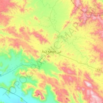
Nom : Carte topographique Keren, altitude, relief.
Lieu : Keren, Anseba, Eritrea (15.62048 38.29361 15.94048 38.61361)
Altitude moyenne : 1 456 m
Altitude minimum : 811 m
Altitude maximum : 2 359 m
Keren (Tigrinya and Tigre: ከረን, Italian: Cheren), historically known as Sanhit, is the second-largest city in Eritrea. It is situated around 91 kilometres (57 mi) northwest of Asmara at an elevation of 1,590 metres (5,220 ft) above sea-level. The city sprawls on a wide basin surrounded by granitic mountains on all sides. It serves as the capital of the Anseba Region, and is home to a number of ethnic groups including the Bilen people and Tigre people.
Autres cartes topographiques
Cliquez sur une carte pour visualiser sa topographie, son altitude et son relief.