
Carte topographique Zgierz County
Carte interactive
Cliquez sur la carte pour afficher l’altitude.
À propos de cette carte
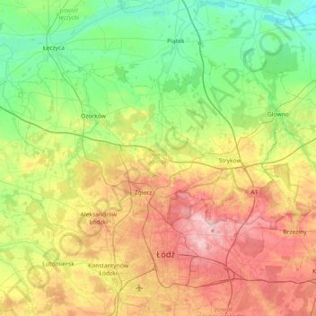
Nom : Carte topographique Zgierz County, altitude, relief.
Lieu : Zgierz County, Łódzkie Voivodship, Poland (51.77123 19.12041 52.03695 19.84003)
Altitude moyenne : 156 m
Altitude minimum : 87 m
Altitude maximum : 281 m
Autres cartes topographiques
Cliquez sur une carte pour visualiser sa topographie, son altitude et son relief.
Seligów
Poland > Łódzkie Voivodship > Łowicz County
Seligów, gmina Łyszkowice, Łowicz County, Łódzkie Voivodship, 99-420, Poland
Altitude moyenne : 114 m
Zgierz
Poland > Łódzkie Voivodship > Zgierz County
Zgierz, Zgierz County, Łódzkie Voivodship, Poland
Altitude moyenne : 193 m
Rybnik
Poland > Łódzkie Voivodship > Sieradz County
Rybnik, gmina Brzeźnio, Sieradz County, Łódzkie Voivodship, 98-275, Poland
Altitude moyenne : 176 m