
Faire un don
Équipez-vous pour votre prochaine aventure :
En tant que Partenaire Amazon, ce site perçoit une commission sur les achats éligibles sans surcoût pour vous.
Carte topographique Rothenfels
Cliquez sur la carte pour afficher l’altitude.
Faire un don
Équipez-vous pour votre prochaine aventure :
En tant que Partenaire Amazon, ce site perçoit une commission sur les achats éligibles sans surcoût pour vous.
Rothenfels
Rothenfels liegt rechts des Mains zwischen Lohr am Main und Marktheidenfeld. Eingezwängt zwischen dem Fluss und einem Steilhang besteht die Stadt aus wenig mehr als einer Hauptstraße. Der topographisch höchste Punkt der Stadtgemarkung befindet sich mit 508 m ü. NHN am Dreßlingkopf, südlich von Aurora, der niedrigste liegt im Main auf 142 m ü. NHN. Seit 2006 wird der Maindamm, Teil der alten und stillgelegten Eisenbahnstrecke Lohr am Main – Wertheim, als Umgehungsstraße genutzt.
Faire un don
Équipez-vous pour votre prochaine aventure :
En tant que Partenaire Amazon, ce site perçoit une commission sur les achats éligibles sans surcoût pour vous.
À propos de cette carte
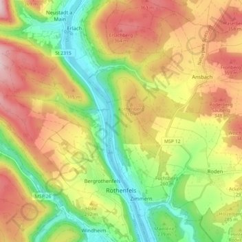
Nom : Carte topographique Rothenfels, altitude, relief.
Altitude moyenne : 270 m
Altitude minimum : 142 m
Altitude maximum : 410 m
Faire un don
Équipez-vous pour votre prochaine aventure :
En tant que Partenaire Amazon, ce site perçoit une commission sur les achats éligibles sans surcoût pour vous.
Autres cartes topographiques
Cliquez sur une carte pour visualiser sa topographie, son altitude et son relief.
Faire un don
Équipez-vous pour votre prochaine aventure :
En tant que Partenaire Amazon, ce site perçoit une commission sur les achats éligibles sans surcoût pour vous.
Neustadt a. Main
Deutschland > Bayern > Landkreis Main-Spessart > Neustadt a.Main
Altitude moyenne : 299 m
Marktheidenfeld
Deutschland > Bayern > Landkreis Main-Spessart > Marktheidenfeld > Marktheidenfeld
Altitude moyenne : 236 m
Gut Ebenroth
Deutschland > Bayern > Landkreis Main-Spessart > Arnstein > Reuchelheim
Altitude moyenne : 297 m
Faire un don
Équipez-vous pour votre prochaine aventure :
En tant que Partenaire Amazon, ce site perçoit une commission sur les achats éligibles sans surcoût pour vous.
Brückenfundamentloch Reichsautobahn Strecke 46, Fulda-Würzburg
Deutschland > Bayern > Landkreis Main-Spessart > Gemünden am Main > Seifriedsburg
Altitude moyenne : 307 m
Faire un don
Équipez-vous pour votre prochaine aventure :
En tant que Partenaire Amazon, ce site perçoit une commission sur les achats éligibles sans surcoût pour vous.
Eichenfürst
Deutschland > Bayern > Landkreis Main-Spessart > Marktheidenfeld > Altfeld
Altitude moyenne : 253 m
Hasberg
Deutschland > Bayern > Landkreis Main-Spessart > Ruppertshüttener Forst
Altitude moyenne : 417 m
Faire un don
Équipez-vous pour votre prochaine aventure :
En tant que Partenaire Amazon, ce site perçoit une commission sur les achats éligibles sans surcoût pour vous.
Faire un don
Équipez-vous pour votre prochaine aventure :
En tant que Partenaire Amazon, ce site perçoit une commission sur les achats éligibles sans surcoût pour vous.
Faire un don
Équipez-vous pour votre prochaine aventure :
En tant que Partenaire Amazon, ce site perçoit une commission sur les achats éligibles sans surcoût pour vous.
Bayerische Schanz (507,9)
Deutschland > Bayern > Landkreis Main-Spessart > Lohr am Main
Altitude moyenne : 491 m
Rengersbrunn
Deutschland > Bayern > Landkreis Main-Spessart > Fellen > Rengersbrunn
Altitude moyenne : 437 m
Faire un don
Équipez-vous pour votre prochaine aventure :
En tant que Partenaire Amazon, ce site perçoit une commission sur les achats éligibles sans surcoût pour vous.
Arnstein
Deutschland > Bayern > Landkreis Main-Spessart > Arnstein > Arnstein
Altitude moyenne : 279 m
Adelsberg
Deutschland > Bayern > Landkreis Main-Spessart > Gemünden am Main > Adelsberg
Altitude moyenne : 246 m
Faire un don
Équipez-vous pour votre prochaine aventure :
En tant que Partenaire Amazon, ce site perçoit une commission sur les achats éligibles sans surcoût pour vous.
Seifriedsburg
Deutschland > Bayern > Landkreis Main-Spessart > Gemünden am Main
Altitude moyenne : 289 m
Langenprozelten
Deutschland > Bayern > Landkreis Main-Spessart > Gemünden am Main
Altitude moyenne : 246 m
Faire un don
Équipez-vous pour votre prochaine aventure :
En tant que Partenaire Amazon, ce site perçoit une commission sur les achats éligibles sans surcoût pour vous.