
Carte topographique Oświęcim
Carte interactive
Cliquez sur la carte pour afficher l’altitude.
À propos de cette carte
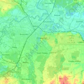
Nom : Carte topographique Oświęcim, altitude, relief.
Lieu : Oświęcim, Oświęcim County, Lesser Poland Voivodeship, Poland (50.00957 19.17785 50.05707 19.33445)
Altitude moyenne : 239 m
Altitude minimum : 222 m
Altitude maximum : 281 m
Autres cartes topographiques
Cliquez sur une carte pour visualiser sa topographie, son altitude et son relief.
Klein
Poland > Lesser Poland Voivodeship > Oświęcim County > Stawy Monowskie > Zalesie
Klein, Zalesie, Stawy Monowskie, gmina Oświęcim, Oświęcim County, Lesser Poland Voivodeship, Poland
Altitude moyenne : 226 m