
Carte topographique Nesconset
Carte interactive
Cliquez sur la carte pour afficher l’altitude.
À propos de cette carte
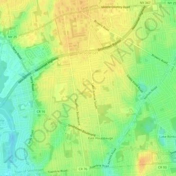
Nom : Carte topographique Nesconset, altitude, relief.
Altitude moyenne : 31 m
Altitude minimum : 13 m
Altitude maximum : 44 m
Autres cartes topographiques
Cliquez sur une carte pour visualiser sa topographie, son altitude et son relief.
Village of Head of the Harbor
United States > New York > Suffolk County > Town of Smithtown
Village of Head of the Harbor, Town of Smithtown, Suffolk County, New York, United States
Altitude moyenne : 35 m
Village of Nissequogue
United States > New York > Suffolk County > Town of Smithtown
Village of Nissequogue, Town of Smithtown, Suffolk County, New York, United States
Altitude moyenne : 19 m
Saint James
United States > New York > Suffolk County > Town of Smithtown
Saint James, Town of Smithtown, Suffolk County, New York, 11780, United States
Altitude moyenne : 39 m