
Carte topographique Ballybritt
Carte interactive
Cliquez sur la carte pour afficher l’altitude.
À propos de cette carte
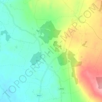
Nom : Carte topographique Ballybritt, altitude, relief.
Altitude moyenne : 146 m
Altitude minimum : 106 m
Altitude maximum : 212 m
Autres cartes topographiques
Cliquez sur une carte pour visualiser sa topographie, son altitude et son relief.
Shinrone
Ireland > County Offaly > The Municipal District of Birr
Shinrone, The Municipal District of Birr, County Offaly, Leinster, Ireland
Altitude moyenne : 72 m
Kilcormac ED
Ireland > County Offaly > The Municipal District of Birr
Kilcormac ED, The Municipal District of Birr, County Offaly, Leinster, R42 RC92, Ireland
Altitude moyenne : 69 m
Seir Kieran
Ireland > County Offaly > The Municipal District of Birr
Seir Kieran, The Municipal District of Birr, County Offaly, Leinster, Ireland
Altitude moyenne : 143 m