
Faire un don
Équipez-vous pour votre prochaine aventure :
En tant que Partenaire Amazon, ce site perçoit une commission sur les achats éligibles sans surcoût pour vous.
Carte topographique Schildow
Cliquez sur la carte pour afficher l’altitude.
Faire un don
Équipez-vous pour votre prochaine aventure :
En tant que Partenaire Amazon, ce site perçoit une commission sur les achats éligibles sans surcoût pour vous.
Schildow
Die nächstgelegene Eisenbahnstation ist der Haltepunkt Mühlenbeck-Mönchmühle der Berliner S-Bahn im Nachbarortsteil Mühlenbeck. Der zentral gelegene Bahnhof Schildow an der „Heidekrautbahn“ hat keinen regelmäßigen Personenverkehr. In Höhe des Bahnübergangs der Mühlenbecker Straße Schillerstraße befand sich der Haltepunkt Schildow-Mönchmühle an der Heidekrautbahn. Dieser wurde zwischenzeitlich abgetragen. Nach Plänen der Niederbarnimer Eisenbahn soll die Station in Schildow sowie die in Mühlenbeck mit der neuen Heidekrautbahn (RB27) wieder errichtet werden.
Faire un don
Équipez-vous pour votre prochaine aventure :
En tant que Partenaire Amazon, ce site perçoit une commission sur les achats éligibles sans surcoût pour vous.
À propos de cette carte
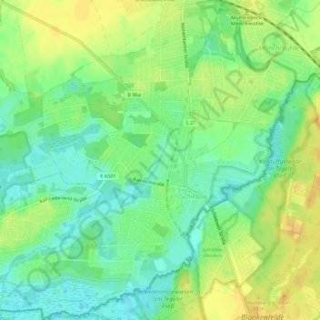
Nom : Carte topographique Schildow, altitude, relief.
Altitude moyenne : 44 m
Altitude minimum : 30 m
Altitude maximum : 58 m
Faire un don
Équipez-vous pour votre prochaine aventure :
En tant que Partenaire Amazon, ce site perçoit une commission sur les achats éligibles sans surcoût pour vous.
Autres cartes topographiques
Cliquez sur une carte pour visualiser sa topographie, son altitude et son relief.
Faire un don
Équipez-vous pour votre prochaine aventure :
En tant que Partenaire Amazon, ce site perçoit une commission sur les achats éligibles sans surcoût pour vous.