
Carte topographique Langdon
Carte interactive
Cliquez sur la carte pour afficher l’altitude.
À propos de cette carte
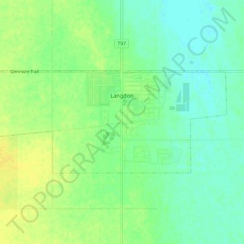
Nom : Carte topographique Langdon, altitude, relief.
Lieu : Langdon, Rocky View County, Alberta, Canada (50.95799 -113.72599 50.97955 -113.64409)
Altitude moyenne : 1 007 m
Altitude minimum : 998 m
Altitude maximum : 1 016 m
Langdon is located 12 km (7.5 mi) east of the City of Calgary at the intersection of Highway 560 (Glenmore Trail) and Highway 797, approximately 6 km (3.7 mi) south of the Trans Canada Highway and 7 km (4.3 mi) north of Highway 22X. It has an elevation of 1,005 m (3,297 ft).
Autres cartes topographiques
Cliquez sur une carte pour visualiser sa topographie, son altitude et son relief.
Bragg Creek
Canada > Alberta > Rocky View County
Bragg Creek, Rocky View County, Alberta, Canada
Altitude moyenne : 1 326 m
Bragg Creek
Canada > Alberta > Rocky View County
Bragg Creek, Rocky View County, Alberta, T0L 0K0, Canada
Altitude moyenne : 1 332 m
Jumping Pound
Canada > Alberta > Rocky View County
Jumping Pound, Rocky View County, Alberta, Canada
Altitude moyenne : 1 253 m
Madden
Canada > Alberta > Rocky View County
Madden, Rocky View County, Alberta, Canada
Altitude moyenne : 1 151 m
Balzac
Canada > Alberta > Rocky View County
Balzac, Rocky View County, Alberta, T0M 0E0, Canada
Altitude moyenne : 1 088 m