
Carte topographique Dunnsville
Carte interactive
Cliquez sur la carte pour afficher l’altitude.
À propos de cette carte
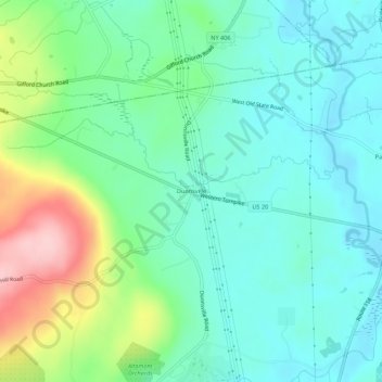
Nom : Carte topographique Dunnsville, altitude, relief.
Altitude moyenne : 130 m
Altitude minimum : 78 m
Altitude maximum : 270 m
Autres cartes topographiques
Cliquez sur une carte pour visualiser sa topographie, son altitude et son relief.
Westmere
United States > New York > Albany County > Town of Guilderland
Westmere, Town of Guilderland, Albany County, New York, United States
Altitude moyenne : 79 m
Village of Altamont
United States > New York > Albany County > Town of Guilderland
Village of Altamont, Town of Guilderland, Albany County, New York, United States
Altitude moyenne : 158 m
Fort Hunter
United States > New York > Albany County > Town of Guilderland
Fort Hunter, Town of Guilderland, Albany County, New York, 12303, United States
Altitude moyenne : 99 m
North Bethlehem
United States > New York > Albany County > Town of Guilderland
North Bethlehem, Town of Guilderland, Albany County, New York, 12203, United States
Altitude moyenne : 65 m
Meadowdale
United States > New York > Albany County > Town of Guilderland
Meadowdale, Town of Guilderland, Albany County, New York, 12085, United States
Altitude moyenne : 115 m
Fullers
United States > New York > Albany County > Town of Guilderland
Fullers, Town of Guilderland, Albany County, New York, 12085, United States
Altitude moyenne : 90 m
Hartmans Corners
United States > New York > Albany County > Town of Guilderland
Hartmans Corners, Town of Guilderland, Albany County, New York, 12084, United States
Altitude moyenne : 81 m
Guilderland Center
United States > New York > Albany County > Town of Guilderland
Guilderland Center, Town of Guilderland, Albany County, New York, 12085, United States
Altitude moyenne : 96 m