
Carte topographique Shake Rag
Carte interactive
Cliquez sur la carte pour afficher l’altitude.
À propos de cette carte
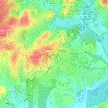
Nom : Carte topographique Shake Rag, altitude, relief.
Altitude moyenne : 300 m
Altitude minimum : 270 m
Altitude maximum : 346 m
Autres cartes topographiques
Cliquez sur une carte pour visualiser sa topographie, son altitude et son relief.
Johns Creek
United States > Georgia > Fulton County > Johns Creek > Johns Creek
Johns Creek, Fulton County, Georgia, 30097, United States
Altitude moyenne : 305 m
Johns Creek
United States > Georgia > Fulton County > Johns Creek
Johns Creek, Fulton County, Georgia, 30097, United States
Altitude moyenne : 314 m