
Carte topographique Techirghiol
Carte interactive
Cliquez sur la carte pour afficher l’altitude.
À propos de cette carte
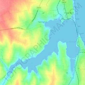
Nom : Carte topographique Techirghiol, altitude, relief.
Altitude moyenne : 23 m
Altitude minimum : -4 m
Altitude maximum : 74 m
Town is in the south east extremity of Romania (Constanța County), situated on the north west shore of Lake Techirghiol (11.6 km2), elevation 15–20 m, 18 km south of the municipality of Constanța and very close to the Black Sea (3 km).
Autres cartes topographiques
Cliquez sur une carte pour visualiser sa topographie, son altitude et son relief.