
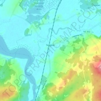
Carte topographique Nappan
Carte interactive
Cliquez sur la carte pour afficher l’altitude.
À propos de cette carte
Nom : Carte topographique Nappan, altitude, relief.
Altitude moyenne : 25 m
Altitude minimum : -2 m
Altitude maximum : 112 m
Autres cartes topographiques
Cliquez sur une carte pour visualiser sa topographie, son altitude et son relief.
Lorneville
Canada > Nova Scotia > Municipality of the County of Cumberland
Lorneville, Municipality of the County of Cumberland, Cumberland County, Nova Scotia, B4H 3X9, Canada
Altitude moyenne : 20 m
Rockley
Canada > Nova Scotia > Municipality of the County of Cumberland
Rockley, Municipality of the County of Cumberland, Cumberland County, Nova Scotia, B0M 1V0, Canada
Altitude moyenne : 24 m
Wentworth Provincial Park
Canada > Nova Scotia > Municipality of the County of Cumberland > Wentworth Station
Wentworth Provincial Park, Valley Road, Wentworth Station, Wentworth, Municipality of the County of Cumberland, Cumberland County, Nova Scotia, B0M 1Z0, Canada
Altitude moyenne : 81 m
Isle Haute
Canada > Nova Scotia > Municipality of the County of Cumberland
Isle Haute, Municipality of the County of Cumberland, Cumberland County, Nova Scotia, Canada
Altitude moyenne : 1 m
Roslin
Canada > Nova Scotia > Municipality of the County of Cumberland
Roslin, Municipality of the County of Cumberland, Cumberland County, Nova Scotia, B0M 1P0, Canada
Altitude moyenne : 34 m
Fenwick
Canada > Nova Scotia > Municipality of the County of Cumberland
Fenwick, Municipality of the County of Cumberland, Cumberland County, Nova Scotia, B0L 1C0, Canada
Altitude moyenne : 79 m