
Faire un don
Équipez-vous pour votre prochaine aventure :
En tant que Partenaire Amazon, ce site perçoit une commission sur les achats éligibles sans surcoût pour vous.
Carte topographique Nellarachal
Cliquez sur la carte pour afficher l’altitude.
Faire un don
Équipez-vous pour votre prochaine aventure :
En tant que Partenaire Amazon, ce site perçoit une commission sur les achats éligibles sans surcoût pour vous.
À propos de cette carte
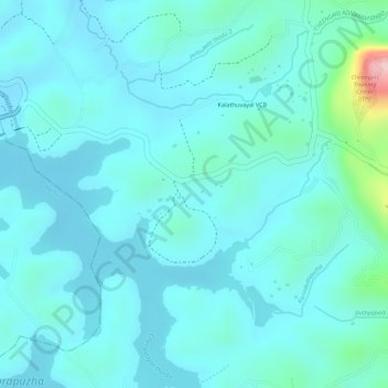
Nom : Carte topographique Nellarachal, altitude, relief.
Lieu : Nellarachal, Sulthanbathery, Wayanad District, Kerala, India (11.60135 76.17809 11.62585 76.19512)
Altitude moyenne : 781 m
Altitude minimum : 745 m
Altitude maximum : 989 m
Faire un don
Équipez-vous pour votre prochaine aventure :
En tant que Partenaire Amazon, ce site perçoit une commission sur les achats éligibles sans surcoût pour vous.
Autres cartes topographiques
Cliquez sur une carte pour visualiser sa topographie, son altitude et son relief.
Sultan Bathery
India > Kerala > Sulthanbathery
Sulthan Bathery is located at 11°40′N 76°17′E / 11.67°N 76.28°E / 11.67; 76.28. It has an average elevation of 907 m (2,976 ft).
Altitude moyenne : 876 m
Faire un don
Équipez-vous pour votre prochaine aventure :
En tant que Partenaire Amazon, ce site perçoit une commission sur les achats éligibles sans surcoût pour vous.
Faire un don
Équipez-vous pour votre prochaine aventure :
En tant que Partenaire Amazon, ce site perçoit une commission sur les achats éligibles sans surcoût pour vous.
Faire un don
Équipez-vous pour votre prochaine aventure :
En tant que Partenaire Amazon, ce site perçoit une commission sur les achats éligibles sans surcoût pour vous.
Sultan Bathery
India > Kerala > Sulthanbathery
Sultan Bathery is located at 11°40′N 76°17′E / 11.67°N 76.28°E / 11.67; 76.28, on the Kozhikode–Kollegal National Highway (NH 766) 97 kilometers from Kozhikode. It is 114 km from Mysore and about 100 km from Ooty (Udagamandalam). It is also connected with Nilambur. It has an average…
Altitude moyenne : 876 m
Sultan Bathery
India > Kerala > Sulthanbathery
Sulthan Bathery is located at 11°40′N 76°17′E / 11.67°N 76.28°E / 11.67; 76.28. It has an average elevation of 907 m (2,976 ft).
Altitude moyenne : 876 m