
Faire un don
Équipez-vous pour votre prochaine aventure :
En tant que Partenaire Amazon, ce site perçoit une commission sur les achats éligibles sans surcoût pour vous.
Carte topographique Tiruvannamalai
Cliquez sur la carte pour afficher l’altitude.
Faire un don
Équipez-vous pour votre prochaine aventure :
En tant que Partenaire Amazon, ce site perçoit une commission sur les achats éligibles sans surcoût pour vous.
Tiruvannamalai
Tiruvannamalai is situated 196 km (122 mi) from the state capital Chennai and 210 km (130 mi) from Bangalore. The height of the Annamalai hill is approximately 2,669 ft (814 m). Tiruvannamalai is located at 12°00′N 79°03′E / 12°N 79.05°E / 12; 79.05. It has an average elevation of 200 metres (660 ft). The city is located to the east of Eastern Ghats. The topography of Tiruvannamalai is almost plain sloping from west to east. The temperature ranges from a maximum of 40 °C (104 °F) to a minimum of 20 °C (68 °F). Like the rest of the state, April to June are the hottest months and December to January are the coldest. Tiruvannamalai receives scanty rainfall with an average of 815 mm (32.1 in) annually, which is lesser than the state average of 1,008 mm (39.7 in). The southwest monsoon with an onset in June and lasting up to August brings scanty rainfall. Bulk of the rainfall is received during the northeast monsoon in the months of October, November and December. The average humidity of the city is 77% and varies between 67% and 86%. During the summer months of April to June, the humidity ranges from 47% to 63%. The municipality covers an area of 16.3 km2 (1,630 ha).
Faire un don
Équipez-vous pour votre prochaine aventure :
En tant que Partenaire Amazon, ce site perçoit une commission sur les achats éligibles sans surcoût pour vous.
À propos de cette carte
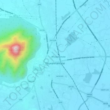
Nom : Carte topographique Tiruvannamalai, altitude, relief.
Lieu : Tiruvannamalai, Tiruvannamalai District, Tamil Nadu, India (12.21239 79.05339 12.26409 79.08889)
Altitude moyenne : 202 m
Altitude minimum : 149 m
Altitude maximum : 788 m
Faire un don
Équipez-vous pour votre prochaine aventure :
En tant que Partenaire Amazon, ce site perçoit une commission sur les achats éligibles sans surcoût pour vous.