
Faire un don
Équipez-vous pour votre prochaine aventure :
En tant que Partenaire Amazon, ce site perçoit une commission sur les achats éligibles sans surcoût pour vous.
Carte topographique Loburn
Cliquez sur la carte pour afficher l’altitude.
Faire un don
Équipez-vous pour votre prochaine aventure :
En tant que Partenaire Amazon, ce site perçoit une commission sur les achats éligibles sans surcoût pour vous.
Loburn
The Loburn-Ashley fault zone is located from the northern banks of the Ashley River through to about Hodgsons road in the north, it runs parallel to the Ashley river. The Loburn fault, which runs along the south side of Hodgsons Road, is responsible for various terraced abandoned stream channels, wedge structures and scarps, notably Round Hill. The topography in Loburn is generally flat with gently rolling hills, altitude gradually decreases southwards from the foothills.
Faire un don
Équipez-vous pour votre prochaine aventure :
En tant que Partenaire Amazon, ce site perçoit une commission sur les achats éligibles sans surcoût pour vous.
À propos de cette carte
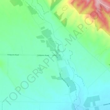
Nom : Carte topographique Loburn, altitude, relief.
Altitude moyenne : 110 m
Altitude minimum : 60 m
Altitude maximum : 253 m
Faire un don
Équipez-vous pour votre prochaine aventure :
En tant que Partenaire Amazon, ce site perçoit une commission sur les achats éligibles sans surcoût pour vous.