
Carte topographique Primorsky Krai
Carte interactive
Cliquez sur la carte pour afficher l’altitude.
À propos de cette carte
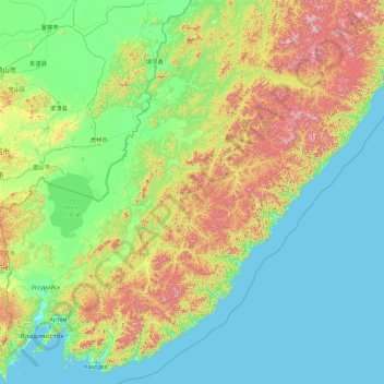
Nom : Carte topographique Primorsky Krai, altitude, relief.
Lieu : Primorsky Krai, Far Eastern Federal District, Russia (42.52195 132.16665 47.64195 137.28665)
Altitude moyenne : 255 m
Altitude minimum : -2 m
Altitude maximum : 1 870 m
Highlands dominate the territory of the krai. Most of the territory is mountainous, and almost 80% of it is forested. The average elevation is about 500 meters (1,600 ft). Sikhote-Alin is a mountainous formation, extending for the most part of the Krai. It consists of a number of parallel ranges: the Partizansky (Partisan), the Siny (Blue), the Kholodny (Cold), and others. There are many karst caves in the South of Primorye. The relatively accessible Spyashchaya Krasavitsa cave (the Sleeping Beauty) in the Ussuriysky Nature Preserve could be recommended for tourists. There are comparatively well-preserved fragments of the ancient volcanoes in the area.
Autres cartes topographiques
Cliquez sur une carte pour visualiser sa topographie, son altitude et son relief.
Vladivostok
Russia > Primorsky Krai > Vladivostok
Vladivostok, Владивостокский городской округ, Primorsky Krai, Far Eastern Federal District, 690000, Russia
Altitude moyenne : 29 m
Slavyanka
Russia > Primorsky Krai > Slavyanka
Slavyanka, Khasansky District, Primorsky Krai, Far Eastern Federal District, Russia
Altitude moyenne : 30 m
Khanka Lake
Khanka Lake, Primorsky Krai, Far Eastern Federal District, 692693, Russia
Altitude moyenne : 79 m