
Faire un don
Équipez-vous pour votre prochaine aventure :
En tant que Partenaire Amazon, ce site perçoit une commission sur les achats éligibles sans surcoût pour vous.
Carte topographique Huangpu District
Cliquez sur la carte pour afficher l’altitude.
Faire un don
Équipez-vous pour votre prochaine aventure :
En tant que Partenaire Amazon, ce site perçoit une commission sur les achats éligibles sans surcoût pour vous.
Huangpu District
The district is pioneering in the low-altitude economy, which includes the development of aerial innovations. Notably, EHang Holdings, based in Huangpu, received the first certification for manned eVTOL (electric vertical take-off and landing) aircraft, positioning the district at the forefront of the urban aerial transportation sector. Huangpu is actively integrating low-altitude economic activities with urban management and tourism, and the district boasts 45 enterprises involved in the low-altitude industrial chain.
Faire un don
Équipez-vous pour votre prochaine aventure :
En tant que Partenaire Amazon, ce site perçoit une commission sur les achats éligibles sans surcoût pour vous.
À propos de cette carte
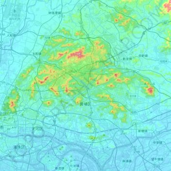
Nom : Carte topographique Huangpu District, altitude, relief.
Lieu : Huangpu District, Guangzhou City, Guangdong Province, China (23.03108 113.39248 23.41549 113.60407)
Altitude moyenne : 45 m
Altitude minimum : -9 m
Altitude maximum : 507 m
Faire un don
Équipez-vous pour votre prochaine aventure :
En tant que Partenaire Amazon, ce site perçoit une commission sur les achats éligibles sans surcoût pour vous.
Autres cartes topographiques
Cliquez sur une carte pour visualiser sa topographie, son altitude et son relief.