
Carte topographique Radeberg
Carte interactive
Cliquez sur la carte pour afficher l’altitude.
À propos de cette carte
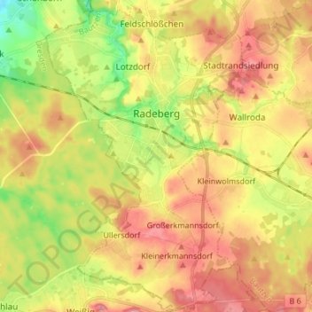
Nom : Carte topographique Radeberg, altitude, relief.
Lieu : Radeberg, Bautzen, Saxony, 01454, Germany (51.06098 13.86944 51.14586 13.95780)
Altitude moyenne : 257 m
Altitude minimum : 200 m
Altitude maximum : 305 m
Autres cartes topographiques
Cliquez sur une carte pour visualiser sa topographie, son altitude et son relief.
Wittichenau - Kulow
Wittichenau - Kulow, Bautzen, Saxony, 02997, Germany
Altitude moyenne : 130 m
Großröhrsdorf
Großröhrsdorf, Bautzen, Saxony, 01900, Germany
Altitude moyenne : 293 m
Kamenz - Kamjenc
Kamenz - Kamjenc, Bautzen, Saxony, Germany
Altitude moyenne : 186 m
Großdubrau - Wulka Dubrawa
Großdubrau - Wulka Dubrawa, Bautzen, Saxony, 02694, Germany
Altitude moyenne : 154 m
Kleindubrau - Mała Dubrawa
Germany > Saxony > Bautzen > Quatitz - Chwaćicy
Kleindubrau - Mała Dubrawa, Quatitz - Chwaćicy, Großdubrau - Wulka Dubrawa, Bautzen, Saxony, Germany
Altitude moyenne : 173 m
Weickersdorf
Germany > Saxony > Bautzen > Bischofswerda
Weickersdorf, Bischofswerda, Bautzen, Saxony, 01877, Germany
Altitude moyenne : 299 m
Koselbruch - Kózło
Germany > Saxony > Bautzen > Hoyerswerda - Wojerecy > Schwarzkollm - Čorny Chołmc
Koselbruch - Kózło, Schwarzkollm - Čorny Chołmc, Hoyerswerda - Wojerecy, Bautzen, Saxony, Germany
Altitude moyenne : 133 m
Bautzen - Budyšin
Bautzen - Budyšin, Bautzen, Saxony, 02625, Germany
Altitude moyenne : 210 m