
Faire un don
Équipez-vous pour votre prochaine aventure :
En tant que Partenaire Amazon, ce site perçoit une commission sur les achats éligibles sans surcoût pour vous.
Carte topographique Kaizhou
Cliquez sur la carte pour afficher l’altitude.
Faire un don
Équipez-vous pour votre prochaine aventure :
En tant que Partenaire Amazon, ce site perçoit une commission sur les achats éligibles sans surcoût pour vous.
À propos de cette carte
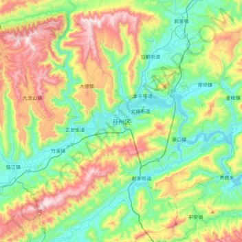
Nom : Carte topographique Kaizhou, altitude, relief.
Lieu : Kaizhou, Kaizhou District, 渝东北三峡库区城镇群, Chongqing, China (31.00266 108.22855 31.32266 108.54855)
Altitude moyenne : 494 m
Altitude minimum : 146 m
Altitude maximum : 1 187 m
Faire un don
Équipez-vous pour votre prochaine aventure :
En tant que Partenaire Amazon, ce site perçoit une commission sur les achats éligibles sans surcoût pour vous.
Autres cartes topographiques
Cliquez sur une carte pour visualiser sa topographie, son altitude et son relief.
Faire un don
Équipez-vous pour votre prochaine aventure :
En tant que Partenaire Amazon, ce site perçoit une commission sur les achats éligibles sans surcoût pour vous.
Faire un don
Équipez-vous pour votre prochaine aventure :
En tant que Partenaire Amazon, ce site perçoit une commission sur les achats éligibles sans surcoût pour vous.
Wanzhou
Wanzhou spans 30°24′−31°14′ N latitude and 107°55′−108°53′ E longitude, and is situated at the eastern edge of the Sichuan Basin. It reaches a maximal north–south extent of 67.25 km (41.79 mi) and east–west width of 97.25 km (60.43 mi), covering an area of 3,214 km2 (1,241 sq mi).…
Altitude moyenne : 651 m
Faire un don
Équipez-vous pour votre prochaine aventure :
En tant que Partenaire Amazon, ce site perçoit une commission sur les achats éligibles sans surcoût pour vous.
Banan District
Banan, situated in the southern part of the Sichuan Basin, has a diversity of terrains including mountains, hills, wetlands and flood beds. The lowest point of the district is on its northern border with Nan'an District, at an altitude of 154 meters. The highest point is the top of Fangdou Mountain in the…
Altitude moyenne : 445 m
Faire un don
Équipez-vous pour votre prochaine aventure :
En tant que Partenaire Amazon, ce site perçoit une commission sur les achats éligibles sans surcoût pour vous.
Jiangjin District
Jiangjin lies within central China at 105°49′—106°38′of longitude and 28°28′—29°28′of north latitude. The landscape and topography of Jiangjin slopes from high elevations in the south and low in the north. Luohuangzhongba stands at the lowest elevation (178.5 m). The highest site, Wugongba in…
Altitude moyenne : 521 m
Faire un don
Équipez-vous pour votre prochaine aventure :
En tant que Partenaire Amazon, ce site perçoit une commission sur les achats éligibles sans surcoût pour vous.
Faire un don
Équipez-vous pour votre prochaine aventure :
En tant que Partenaire Amazon, ce site perçoit une commission sur les achats éligibles sans surcoût pour vous.
Faire un don
Équipez-vous pour votre prochaine aventure :
En tant que Partenaire Amazon, ce site perçoit une commission sur les achats éligibles sans surcoût pour vous.
Pengshui Miao and Tujia Autonomous County
China > Chongqing > Pengshui Miao and Tujia Autonomous County
Altitude moyenne : 926 m