
Carte topographique Weißenohe
Carte interactive
Cliquez sur la carte pour afficher l’altitude.
À propos de cette carte
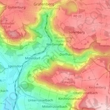
Nom : Carte topographique Weißenohe, altitude, relief.
Altitude moyenne : 442 m
Altitude minimum : 320 m
Altitude maximum : 547 m
Autres cartes topographiques
Cliquez sur une carte pour visualiser sa topographie, son altitude et son relief.
Effeltrich
Germany > Bavaria > Landkreis Forchheim
Effeltrich, Effeltrich (VGem), Landkreis Forchheim, Bavaria, 91090, Germany
Altitude moyenne : 322 m
Albertshof
Germany > Bavaria > Landkreis Forchheim > Wiesenttal
Albertshof, Wiesenttal, Landkreis Forchheim, Bavaria, 91346, Germany
Altitude moyenne : 429 m
Burk
Germany > Bavaria > Landkreis Forchheim > Forchheim
Burk, Forchheim, Landkreis Forchheim, Bavaria, 91301, Germany
Altitude moyenne : 292 m
Egloffstein
Germany > Bavaria > Landkreis Forchheim > Egloffstein > Egloffstein
Egloffstein, Landkreis Forchheim, Bavaria, 91349, Germany
Altitude moyenne : 461 m