
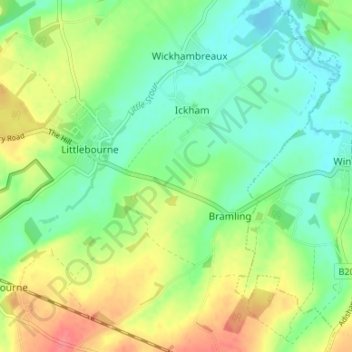
Carte topographique Ickham and Well
Carte interactive
Cliquez sur la carte pour afficher l’altitude.
À propos de cette carte
Nom : Carte topographique Ickham and Well, altitude, relief.
Altitude moyenne : 23 m
Altitude minimum : 0 m
Altitude maximum : 60 m
Autres cartes topographiques
Cliquez sur une carte pour visualiser sa topographie, son altitude et son relief.
Petham
United Kingdom > England > Canterbury > Petham
Petham, Canterbury, Kent, South East, England, CT4 5QX, United Kingdom
Altitude moyenne : 94 m
Bridge
United Kingdom > England > Canterbury > Bridge
Bridge, Canterbury, Kent, South East, England, CT4 5LD, United Kingdom
Altitude moyenne : 55 m
Chartham
United Kingdom > England > Canterbury > Chartham
Chartham, Kent, South East, England, CT4 7JQ, United Kingdom
Altitude moyenne : 54 m
Hambrook Marshes
United Kingdom > England > Canterbury
Hambrook Marshes, A2, Harbledown and Rough Common, Canterbury, Kent, South East, England, CT2 9DN, United Kingdom
Altitude moyenne : 30 m
Waltham
United Kingdom > England > Canterbury > Waltham
Waltham, Canterbury, Kent, South East, England, CT4 5SE, United Kingdom
Altitude moyenne : 127 m
Chislet
United Kingdom > England > Canterbury
Chislet, Canterbury, Kent, South East, England, United Kingdom
Altitude moyenne : 10 m
Canterbury Castle
United Kingdom > England > Canterbury
Canterbury Castle, Gas Street, St. Mildred's, Canterbury, Kent, South East, England, CT1 2PR, United Kingdom
Altitude moyenne : 27 m
Bekesbourne-with-Patrixbourne
United Kingdom > England > Canterbury
Bekesbourne-with-Patrixbourne, Canterbury, Kent, South East, England, United Kingdom
Altitude moyenne : 50 m
Fordwich
United Kingdom > England > Canterbury > Fordwich
Fordwich, Kent, South East, England, CT2 0DB, United Kingdom
Altitude moyenne : 32 m