
Carte topographique Gemeinde Sibratsgfäll
Carte interactive
Cliquez sur la carte pour afficher l’altitude.
À propos de cette carte
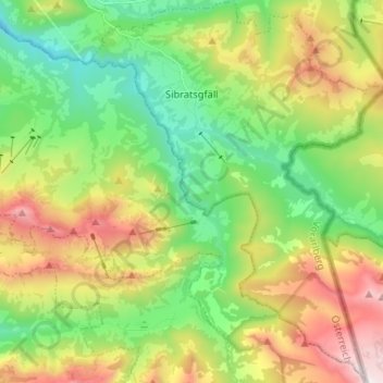
Nom : Carte topographique Gemeinde Sibratsgfäll, altitude, relief.
Lieu : Gemeinde Sibratsgfäll, Bezirk Bregenz, Vorarlberg, Austria (47.35986 10.00391 47.44831 10.10559)
Altitude moyenne : 1 245 m
Altitude minimum : 747 m
Altitude maximum : 2 036 m
Sibratsgfäll is located in the westernmost province of Austria, Vorarlberg, in the district of Bregenz, east of Lake Constance, at an altitude of 929 meters. 46.0% of the area is forested, 34.2% mountainous (Alps). The community is located directly on the border with Germany. There are no other cadastral communities in Sibratsgfäll.
Autres cartes topographiques
Cliquez sur une carte pour visualiser sa topographie, son altitude et son relief.
Gemeinde Schwarzach
Austria > Vorarlberg > Bezirk Bregenz
Gemeinde Schwarzach, Bezirk Bregenz, Vorarlberg, 6858, Austria
Altitude moyenne : 507 m