
Carte topographique ایبٹ آباد
Carte interactive
Cliquez sur la carte pour afficher l’altitude.
À propos de cette carte
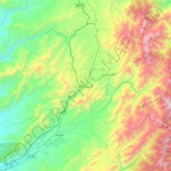
Nom : Carte topographique ایبٹ آباد, altitude, relief.
Lieu : ایبٹ آباد, Jaiber Pastunjuá, 22010, Pakistán (33.98361 73.05327 34.30361 73.37327)
Altitude moyenne : 1 363 m
Altitude minimum : 554 m
Altitude maximum : 2 924 m
Abbottabad (urdu: ایبٹ آباد) es una ciudad situada en la provincia de Khyber Pakhtunkhwa de Pakistán. La ciudad está situada en el Valle Orash, 120 km al norte de Islamabad y 200 kilómetros al este de Peshawar, a una altitud 1227 m. La ciudad es conocida en todo Pakistán por su clima agradable, las instituciones educativas de alto estándar y establecimientos militares. Sigue siendo un centro importante de turismo de las zonas del norte de Pakistán en el verano.
Autres cartes topographiques
Cliquez sur une carte pour visualiser sa topographie, son altitude et son relief.
نوشاخ
نوشاخ, Chitrāl District, Jaiber Pastunjuá, Pakistán
Altitude moyenne : 6 863 m
Mate
Pakistán > Jaiber Pastunjuá > Mate
Mate, Kohistān District, Jaiber Pastunjuá, Pakistán
Altitude moyenne : 1 371 m
Tirich Mir
Tirich Mir, Chitrāl District, Jaiber Pastunjuá, Pakistán
Altitude moyenne : 6 886 m
Chitral
Pakistán > Jaiber Pastunjuá > Chitral
Chitral, Chitrāl District, Jaiber Pastunjuá, Pakistán
Altitude moyenne : 2 047 m
Istor-o-Nal
Istor-o-Nal, Chitrāl District, Jaiber Pastunjuá, Pakistán
Altitude moyenne : 6 853 m